


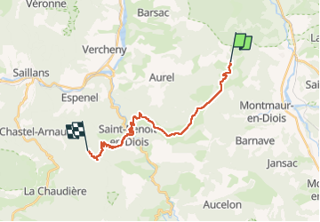
traversé de la Drôme par Hexatrek etap2

taguette
User

Length
20 km

Max alt
1157 m

Uphill gradient
675 m
Km-Effort
31 km

Min alt
348 m

Downhill gradient
992 m
Boucle
No
Creation date :
2024-04-12 07:33:44.403
Updated on :
2024-04-12 16:09:34.184
8h34
Difficulty : Very difficult

FREE GPS app for hiking
 SityTrail
IGN / Geographical institutes
SityTrail Plus
The world is yours!
About
Trail Walking of 20 km to be discovered at Auvergne-Rhône-Alpes, Drôme, Solaure en Diois. This trail is proposed by taguette.
Positioning
Country:
France
Region :
Auvergne-Rhône-Alpes
Department/Province :
Drôme
Municipality :
Solaure en Diois
Location:
Aix-en-Diois
Start:(Dec)
Start:(UTM)
686299 ; 4952707 (31T) N.
Comments